
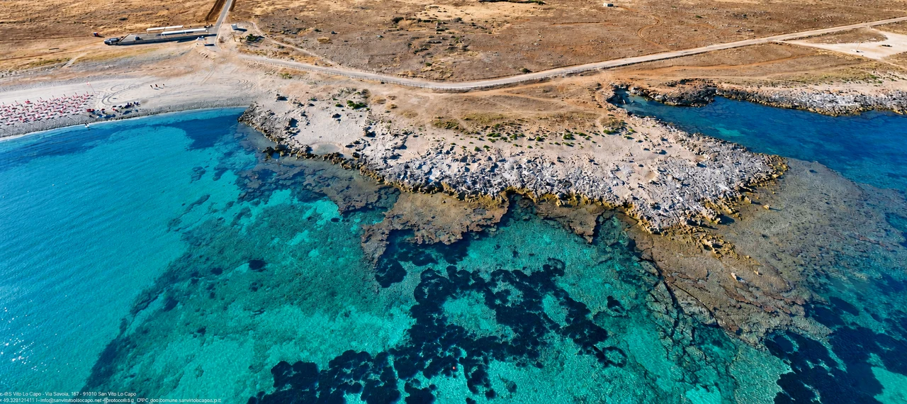
There is more than one kind of coast here: sand and facilities beside the village, pebbles and rock around Macari and Castelluzzo, and walking trails to Zingaro’s coves. Use the names, shore types and access details below to plan your day.
What kind of beach day?
Sand and convenience
San Vito Lo Capo for the village on your doorstep; Baia Santa Margherita for a beach outside town.
San Vito · Santa MargheritaPebbles and rock
Bue Marino, Isulidda and Agliareddi: choose by water access and conditions, rather than a photograph alone.
Bue Marino · IsuliddaWalking and swimming
Zingaro’s coves call for suitable shoes, water and a plan that includes the return walk.
Choose a cove and entranceFind your bearings: west coast, village and Zingaro
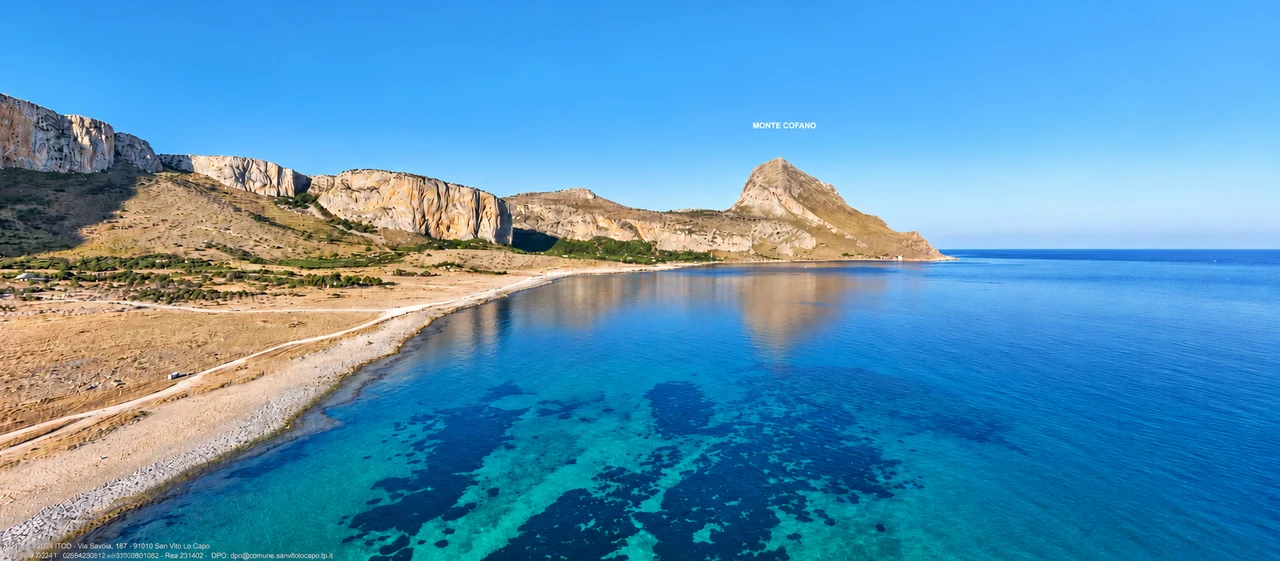
Macari and Castelluzzo face west towards the Gulf of Monte Cofano. San Vito’s beach fronts the village; Tonnara del Secco and Zingaro lie on the other side of the peninsula.
The interactive map is provided by OpenStreetMap and loads only when you press the button. The provider will receive your IP address and technical request data.
Open the map in a new tab ↗Save the map before heading out. A map does not replace opening notices or signs; not every marked line represents a route currently open.
A day by the sea without a car: shuttles from San Vito
SALE E MULINI · A/R
Santa Margherita Bay · Macari and Castelluzzo
Plan a day on the western coast with departure from San Vito and collection at your hotel or apartment. The shuttle serves Santa Margherita Bay, between Macari and Castelluzzo; it does not serve every individual cove.
The listing offers two indicative departure/return combinations: 09:00–16:00 or 10:30–17:30, daily except Saturday. Published prices: adults €10, children aged 3–10 €7. Booking required, subject to availability and a minimum of 3 passengers.
View and request the bay shuttle ↗SALE E MULINI · A/R
Zingaro · north entrance
Request a transfer from San Vito to the northern side of the reserve, with collection and return at your hotel or apartment. Continue on foot after arrival and allow time to reach the agreed meeting point for the return journey.
Published indicative departure/return times are 08:30–15:30 and 10:00–17:30. Adults €15 per person return; children aged 0–2 travel free. Departures are subject to availability, advance booking and at least 4 participants. Ask separately about reserve admission charges and conditions.
View and request the Zingaro shuttle ↗Times and prices reflect the service listings checked on 29 October 2026: confirm seasonal operation, availability, pickup point and price before booking. For Zingaro, bring water and closed shoes and check the reserve manager’s notices. +39 0923 974429
San Vito, Macari and Castelluzzo: beach by beach
“Open map” searches for the named location. These are not walking tracks: use permitted access and local signs for the final approach.
01 / Village
San Vito Lo Capo
- Shore and seabed
- Pale sand; a sandy seabed that generally shelves gradually.
- Getting there
- The beach fronts the village and is reached on foot from the seafront. Drivers should use permitted parking areas and walk the last stretch.
- Facilities
- Free beach areas and paid beach facilities; cafés and restaurants in the village.
- Before choosing
- A practical choice for sand, nearby facilities and a day without driving. Confirm accessible walkways and assistance with the selected operator.
02 / Castelluzzo / Macari
Baia Santa Margherita
- Shore and seabed
- A sandy beach in the Gulf of Monte Cofano, edged by rocky shoreline.
- Getting there
- Access is from the coastal area below Castelluzzo and Macari. Summer traffic restrictions may apply: follow signed parking and beach access.
- Facilities
- Seasonal beach facilities; check availability and opening dates.
- Before choosing
- An alternative to the village beach for sand and wider coastal scenery. Do not assume a shuttle, tourist train or free parking is operating.
03 / Macari
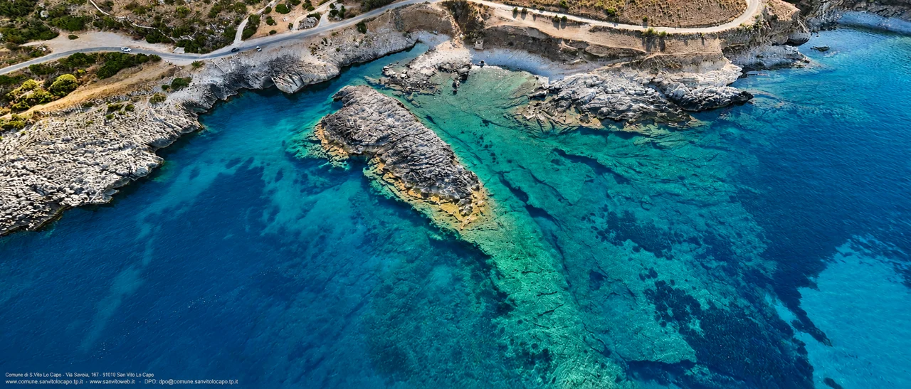
Cala del Bue Marino
- Shore and seabed
- Pebbles and rock; entering the water differs from a sandy beach.
- Getting there
- Below the viewpoint on the road between Macari and San Vito; the final approach is on foot. Do not stop on the carriageway to reach it.
- Facilities
- Bring water and sun protection; do not rely on facilities directly in the cove.
- Before choosing
- For visitors who enjoy pebbles and clear water. Water shoes can help; waves can make getting out over the pebbles difficult.
04 / Macari
Cala dell’Isulidda
- Shore and seabed
- A small cove of pebbles and rock, facing the little island that gives it its name.
- Getting there
- Walk down from the Isulidda area. Check the permitted parking place and usable path on arrival.
- Facilities
- Facilities are not comparable with the village beach; bring what you need.
- Before choosing
- An option for observing the seabed with a mask, only in suitable conditions and close to an easy exit.
05 / Castelluzzo
Calazza / Seno dell’Arena
- Shore and seabed
- A small beach among rocks, combining sand and rocky shoreline.
- Getting there
- From the Castelluzzo coastal road, continue on foot to the cove. The name Seno dell’Arena also appears on local maps.
- Facilities
- A natural setting: bring water, shade and a bag to take litter away.
- Before choosing
- For a small-scale beach stop; leave paths clear and avoid damaging coastal vegetation.
06 / Castelluzzo
Scaru Brucia
- Shore and seabed
- Low rocks with a small indentation at the water’s edge.
- Getting there
- From the Castelluzzo coast, with a final walk over natural ground.
- Facilities
- Not an equipped beach: bring water and suitable footwear.
- Before choosing
- For those who prefer rocky platforms to sand. Identify your exit before entering; wet rock is slippery.
07 / Castelluzzo
Scaru Zu Asparu
- Shore and seabed
- A small bay with sandy patches and rock around its edges.
- Getting there
- Reached from the coastal strip below Castelluzzo, then on foot. Maps may spell the name Zu Asparo or Zu Asparu.
- Facilities
- Bring your supplies; do not plan around an equipped beach club.
- Before choosing
- Check the water entry and any small-boat movements; keep slipways and access gaps clear.
08 / Towards Monte Cofano
Agliareddi / Agliarelli
- Shore and seabed
- A pebbly cove on the coast approaching the reserve.
- Getting there
- Access from the Castelluzzo coastal area, with an approach on foot.
- Facilities
- Plan a self-sufficient visit; little natural shade.
- Before choosing
- The water can become deep quickly: do not choose the cove solely because the surface looks calm.
09 / West coast
Cala Mancina
- Shore and seabed
- Rocky coast beneath the cliffs, with small inlets.
- Getting there
- Approach on foot from the Cala Mancina area, using permitted paths and respecting private land and fences.
- Facilities
- Not comparable with an equipped beach: plan a self-sufficient stop.
- Before choosing
- Choose it for cliff scenery rather than the convenience of a sandy beach. The cliffs are also a climbing area.
10 / East coast
Tonnara del Secco
- Shore and seabed
- Rocky shoreline in front of the former tuna-fishing complex.
- Getting there
- From the road to Tonnara del Secco, use permitted coastal access. The buildings are not a visitor facility.
- Facilities
- Do not assume beach facilities are available at the tuna-fishing complex.
- Before choosing
- For coastal scenery and maritime heritage. Do not enter abandoned buildings or cross restricted areas.
Zingaro’s seven coves: north to south
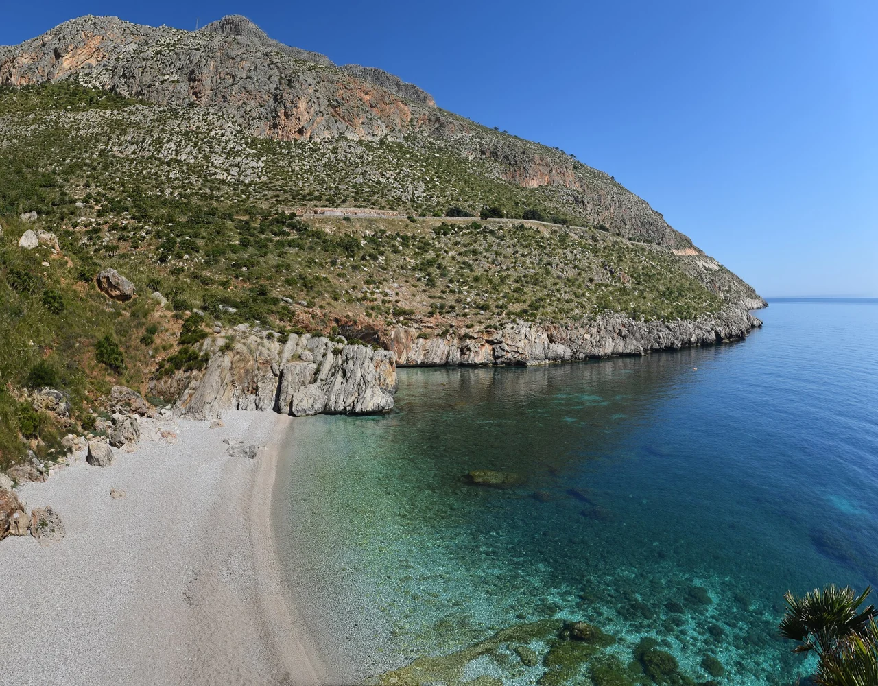
From San Vito use the north entrance; from Scopello the south entrance. No road runs through the reserve. Visiting a cove is part of a walking trip: do not count on beach clubs or refreshment stops. Bring water, lunch, a hat and closed shoes.
| Cove | What to expect | Access and map |
|---|---|---|
| Tonnarella dell’Uzzo | Pale pebbles; the first cove from San Vito. Around 700 m from the north entrance, plus the descent to the shore. | Nord / North Map ↗ |
| Cala dell’Uzzo | A pebbly beach in the Uzzo area; continue from the north along the signed coastal trail. | Nord / North Map ↗ |
| Cala Marinella | A small rocky inlet, rather than a broad beach with room for rows of umbrellas. | Nord / North Map ↗ |
| Cala Berretta | A cove in the central part of the reserve; a longer walk than the beaches near the entrances. | Sentiero costiero / Coastal trail Map ↗ |
| Cala della Disa | Pebbles and rock walls. Check for restrictions on the descent or beach even when the reserve itself is open. | Sud / South Map ↗ |
| Cala del Varo | Visible from the coastal path; access to the cove is by sea. Do not attempt improvised descents down the rocks. | Via mare / By sea Map ↗ |
| Cala Capreria | A pebbly cove on the Scopello side, the first beach along the coastal trail from the south entrance. | Sud / South Map ↗ |
An open reserve does not mean every descent to the sea is accessible. Check the manager’s notices and entrance signs; ask the ticket office which coves can be reached that day. Reserve notices ↗
Practical details that make a difference
Parking and the final walk
In the village, plan parking and any restricted traffic zones before driving to the seafront. For coves, a Google Maps result is not permission to drive on tracks, enter private land or park on the roadside. Charges, shuttles and summer restrictions depend on the season and municipal rules. Getting here and around.
Children and accessibility
For fewer transfers with pushchairs and bags, start with the village beach. If assistance is needed to enter the water, confirm walkways, beach wheelchairs, accessible toilets and availability before visiting. Easy road access does not necessarily mean an accessible waterline. Pebbles, steps and rocks require individual assessment.
Wind, waves and snorkelling
Compare the wind forecast with the waves actually present. The west and east coasts can have different conditions, but no cove is always sheltered. Identify your exit before swimming; when snorkelling stay near shore and clear of boat channels. Leave shells, rocks and living organisms in place.
Public Archive of the Municipality of San Vito Lo Capo · SanVitoVirtual, created by Francesco Ferla.
Sources and updates
Editorial review: 29 October 2026. Descriptions are independently written; access and seasonal facilities may change.